Bachelor Thesis
Examples of recently completed projects are listed below.
A complete list is located at the bottom of this page.
Applying Machine Learning to C-band and X-band
SAR Images for Sea Ice Classification
Student: Gloria Vergés
Supervisors: Dr. Lanqing Huang and Prof. Irena Hajnsek
Time period: 2023 Spring Semester
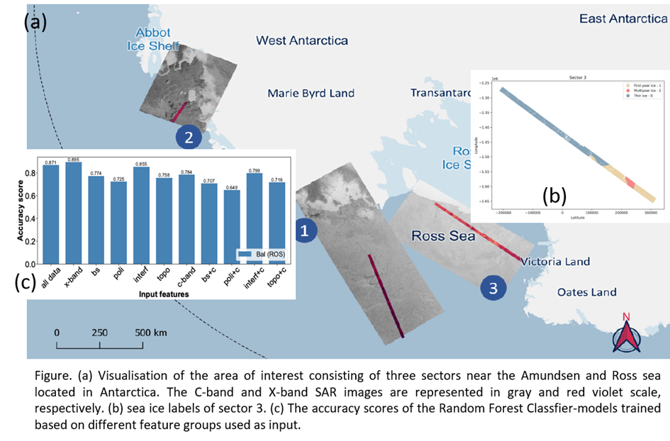
The aim of this bachelor thesis was to investigate whether information (features) derived from multi-frequency SAR imagery could enhance sea ice classification using a random forest classifier (RFC). The "Ice Chart" product (U.S. National Ice Center, 2020) served as ground truth to label the data. The question was researched by using Sentinel-1 (C-band) and TanDEM-X SAR data (X-band).
The Sentinel-1 and Tan-DEM-X acquisitions overlapped in three distinct sectors within the regions of the Amundsen and Ross Sea in Antarctica, with a temporal gap of approximately 30 minutes. Sixteen X-band features and three C-band features were retrieved and categorized as backscattering, interferometric, polarimetric and topographic based features. The data processing involved image rescaling, merging the high resolution features, as well as co-locating the features with the ground truth and labelling each pixel accordingly.
The results shows that the X-band features based model scored a significantly better accuracy value (0.895) than the model based solely on the C-band features (0.784). Two out of the three C-band features were ranked under the top 10 most important features, indicating that C-band features are important.
Nevertheless, the inclusion of C-band features lowered the accuracy score, which suggest that the inclusion of C-band features does not improve prediction accuracy despite their importance.
Applying machine learning to C-band and X-band
SAR images for snow and ice freeboard retrieval
Student: Robin Gisin
Supervisor: Dr. Lanqing Huang and Prof. Irena Hajnsek
Time period: 2023 Spring Semester
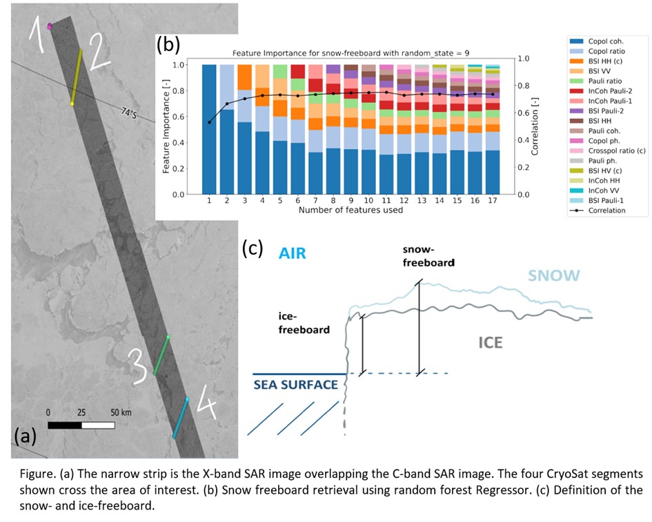
This thesis studies the potential of using machine learning models with multi-frequency synthetic aperture radar (SAR) imagery to estimate the elevation of sea ice. Random Forest Regression, a widely used machine learning model, is applied to predict the ice freeboard and snow freeboard using X-band data from the TanDEM-X mission and C-band data from the Sentinel-1 mission. The study uses data on the ice freeboard obtained from the CryoSat mission as the target variable, which is spatially and temporally filtered for alignment with the SAR data. Before applying the Random Forest Regression the two target variables are compared. The natural relationship that the snow freeboard tends to be greater because of the additional snow can be confirmed. The results from the model for the ice freeboard are not very significant, as insufficient data leads to a dependency on the randomness. Also, the RMSE is approximately 50% of the average ice freeboard. For the snow freeboard a clear positive correlation of 0.76 for the mutli-frequency input and a RMSE of 20% is achieved. The model shows that the combination of multi-frequency SAR imagery can improve the result for predicting the snow freeboard, as one of the top three features is the backscattering intensity HH from C-band.
Full List of BSc Theses
2023
Gloria Vergés: Applying Machine Learning to C-band and X-band SAR Images for Sea Ice Classification
Robin Gisin: Applying machine learning to C-band and X-band SAR images for snow and ice freeboard retrieval
2022
Natalie Stalder: Analysing sea ice topography using remote sensing images
Raffael Bucher: Monitoring Retrogressive Thaw Slumps on the Taymyr Peninsula
2021
Micha Walder: Monitoring Retrogressive Thaw Slumps in the Taymyr Peninsula using Optical Satellite Images
2020
Martina Buck: Multi-channel stacking for glacier offset tracking: a proof-of-concept study using multi-spectral data from Sentinel-2A
Enrico Bernardini: Analysis of two large-volume glacier detachments in the Petra Pervogo range, Tajikistan
Giorgio Laghi: Property extraction of retrogressive thaw slumps in the Canadian high Arctic using TanDEM-<<x and ArticDEM Dat
2019
Bär Michael Alexander: Comparing models for Ku-Band radar backscatter of dry snow
Bichsel Nina: Monitoring Retrogressive Thaw Slumps in the Arctic using optical Satellite Images
Cremona Aaron: ArcticDEM and TandDEM-X: Accuracy assessment and application o retrogressive thaw slumps monitoring
Holenstein Sämi Christoph: Generation of an avalanche map for entire Switzerland from Sentinel-1 radar images
Metzger Jona: Geschwindigkeit des Rhonegletschers basierend auf TanDEM-X und Sentinel-2 Daten
2018
Behler, Selina: Identification of hazardous surge-type glaciers on the Tipetan Plateau
Willimann, Cyril: Hazard analysis of recently identified glacier detachment in the West Kunlun Shan
2017
Hagspiel, Nick: Tracking the Evolution of Agricultural Crops with SAR Interferometry and SAR Polarimetry
Kuhn, Alexandra: Satellite Observation of Velocity Variations of Grosser Aletschgletscher
Lück, Ilona: Polarimetric Diversity in Ku-Band Differential Interferometric Observations of an Alpine Glacier
von Ah, Florian: Identifikation von surgenden Gletschern auf der tibetischen Hochebene
2016
Rigo, Elvira: Explainig the Changes in the Polarimetric Descriptors Based on the Changes in the Rice Crop Morphology
2015
Stoppa, Francesco: Topography-based simulation of SAR backscatter image
Xingyu, Liu: Analyse interferometrischer SAR-Daten über dem Lena-Delta (Sibirien)
Kirchhoff, Frederic: Applicaton of SAR polarimerty to the monitoring of agricultural crop structure
2014
Rulli, Romina: Detection of Small Icebergs with Quad-Polarimetric SAR
Sperger, Katharina: Detecting the Great Pacific Garbage Patch Using Synthetic Aperture Radar
2013
Pohl, Thomas: Analyse von Radaraufnahmen in L- und P-Band vom Tropischen Regenwald
Roth, Simon: Observation of Sea Ice with Polarimetric Synthetic Aperture Radar.