Radar & SAR Techniques
Synthetic aperture radar (SAR) is a widely used tool for radar remote sensing of the Earth. Be it the geosphere, cryosphere, hydrosphere, or the biosphere, radar & SAR techniques are pertinent to the monitoring and estimation of various environmental parameters. At the Chair of Earth Observation and Remote Sensing, we develop and advance such techniques, and in turn use them to investigate spatio-temporal features of several geophysical phenomena. For more information please inquire at .
SAR Interferometry
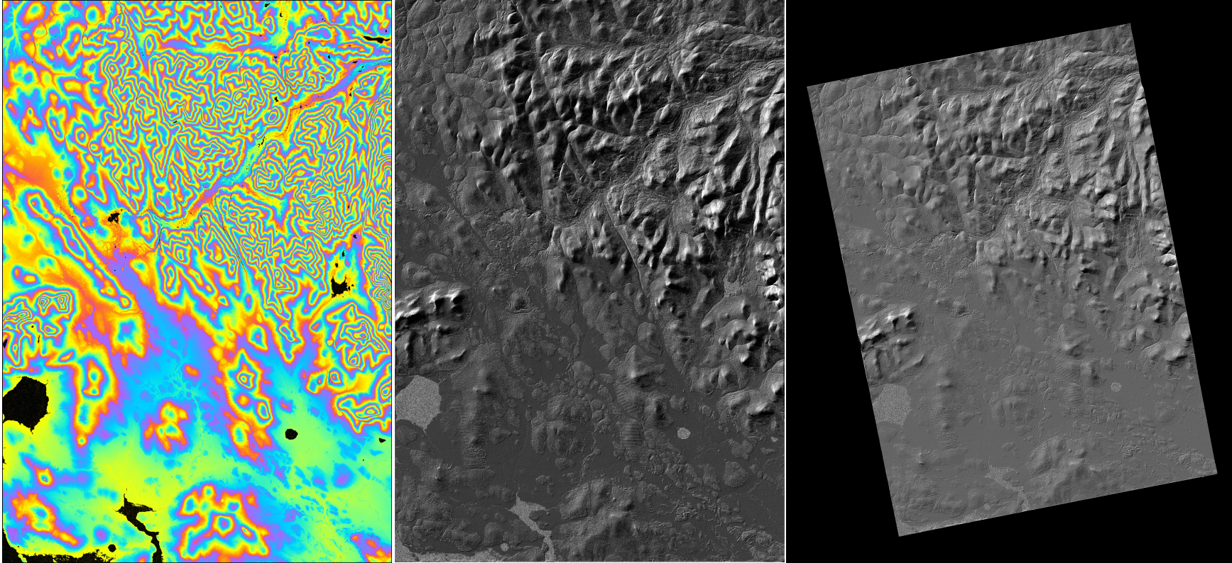
The interferometric phase among a pair of complex SAR images may contain several phase components, such as those related to topography, surface deformation, atmosphere refractivity changes, soil moisture, etc. besides measurement noise and decorrelation. Often, specific to an application, one phase component is relevant while the others tend to act as disturbances. Sophisticated processing techniques, as well as an appropriate selection of sensors, are employed to extract the relevant components while mitigating the disturbances.
As an example, the topography-correlated phases can be extracted to synthesize high resolution digital elevation models (DEMs), such as the following DEM generated from a pair of TanDEM-X acquisitions:
By differencing DEMs generated at different instants in time, we can perform change detection. The following image shows an application of this technique to monitor changes in the permafrost in the Mackenzie River Delta, Canada:

In differential SAR intereferometric (DInSAR) approaches, the topographic phase component is removed to extract a deformation map, while carefully mitigating the sources of decorrelation and other disturbances. The centimetre accuracies that can be achieved have made this technique useful for characterizing many processes and movements, such as those related to volcanic activities, the movement of glaciers, or subsidence caused by permafrost-thaw. This measurement works by combining two radar acquisitions from different times. During this time gap, the moisture content of the soil can change and such changes can impact the DInSAR signals and thus the deformation estimates. Analysis of satellite and airborne measurements, as well as dedicated experiments using the group's ground-based radar systems can help characterize the properties and magnitudes of these effects. The end goals are:
- to model the effect of soil moisture changes in mineral and organic soils on DInSAR measurements
- to elucidate the impact of vegetation dynamics on these measurements
- to estimate soil moisture changes and vegetation parameters from radar data
- to improve deformation estimates by correcting for these effects and quantifying the associated uncertainties
Persistent Scatterer Interfereometry (PSI)
DInSAR methods exploit the temporal baselines among one or more interferograms to extract the phase components correlated with scatterer motion. The performance of these methods is limited by the presence of unwanted phase components, such as the atmospheric phase screen (APS), and phase degradation caused by temporal and geometric decorrelations. Persistent scatterer interferometry (PSI) is an advanced DInSAR concept that circumvents these limitations by observing the phase histories of the so-called persistent scatterers (PSs) in a relatively large stack of interferograms. These are single dominant point-like scatterers marked by high temporal coherence across the entire stack. Since they are less susceptible to the decorrelation phenomena, their unknown motion parameters can be more reliably estimated. A large quantity of PSs is generally desired to effectively retrieve information about the observed geophysical process. PSI techniques are used to analyse deformation signals in urban and alpine regions.
SAR Tomography
SAR tomography extends the conventional 2D SAR imaging to 3D, by synthesizing a synthetic aperture in the direction normal to the range-azimuth plane, by using multiple acquisitions taken from slightly different viewing angles. This additional dimension directly provides the solution of the target elevation ambiguity problem faced by the conventional SAR which cannot separate targets appearing in the same range cell despite their different elevations. The image profile in the normal-to-slant range direction (elevation) separates these targets. Differential SAR tomographic techniques simultaneously allow modeling the motion parameters of one or more scatterers in addition to their elevation. In this way, differential SAR tomography can be used as a technique for deformation assessment.
Combined use of PSI and SAR tomography is being investigated to improve deformation analysis in urban regions and alpine territories.

SAR Polarimetry (PolSAR) & Polarimetric InSAR (Pol-InSAR)
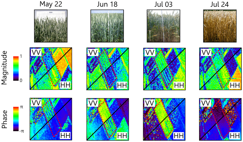
PolSAR exploits multiple wave polarizations to sense the polarization dependence of the backscattering response of a target and infer additional information about its structural and dielectric properties. It can be used to study the characteristics of vegetation and forest canopy. It can potentially discriminate the contributions from the vegetated layer and the soil by means of polarimetric decompositions. However, the use of different polarizations alone may not provide, in some cases, sufficient information to separate the scattering contributions from the canopy and the ground. Exploiting the sensitivity of the interferometric coherence to polarization, i.e. by employing a technique called Pol-InSAR, can provide further insights into the geo/biophysical properties of a vegetated surface. This technique allows for the quantitative estimation of parameters related to the structure and distribution of scatterers within the canopy (e.g. vegetation height and plant orientation), and the relative scattering contributions from the canopy and the ground.

Ground-based radar remote sensing

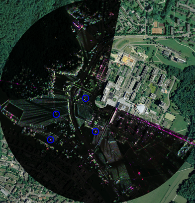
We are equipped with a ground based real aperture radar interferometer. It is a Ku band real aperture FMCW radar, which offers a range resolution of 0.75 m and an azimuth resolution of 0.4 degrees. With the addition of vertically and horizontally polarized antennas, this model allows to acquire a fully polarimetric, interferometric data set in a single pass. This is of interest for terrain mapping (generation of DEMs), deformation measurement and agricultural applications. Because of its portability and fast acquisition rates, it makes very easy and interesting for us to experiment with different acquisition configuration, time scales and locations.
